BUCA'S BACKYARD: YÖRÜK VILLAGES
– Preface –
Buca Plain, located near the historical Izmir-Ephesus road and Izmir (Smyrna), one of the most important port cities of the Aegean, has been home to different civilizations throughout history. It had a cool climate and soil suitable for agriculture, away from the humidity brought by the hot waters of the Aegean, receiving breezes from the surrounding hills. In addition, it did not suffer from water shortage thanks to the hills surrounding it on three sides. When you crossed the hills that cut the Buca Plain from the east and came to the lands adjacent to the foothills of Mount Nif, the temperature decreased as the altitude increased, water resources increased and fertile lands continued.
Today, Buca Plain is completely buried under apartment buildings. However, rural life still continues in the villages adjacent to Nif Mountain in the east of Buca. Of course, there are no old ways. Mechanization in agriculture has already arrived here. According to the villagers, livestock farming has also been largely abandoned. So, nothing remains the same around here. However, there is still no major construction. When you go to the villages, you can still be thankful that these villages, right next to the huge Buca, remain as untouched as possible.
When the region is examined from a historical perspective, which is the main purpose of the article, some old written sources give us surprising and exciting information. Aristote Fontrier, a Frenchman who lived in Izmir, published a book called "Lembos Monastery" in 1892. In the book, he talks about some ancient settlements to the west of Mount Nif. We will talk a lot about these ancient settlements in the future. We are traveling forward in history and we can understand from past documents and maps that there were villages in this region during the Ottoman Period. In other words, there have always been settlements dating back to ancient times, not only in Buca but also around it.
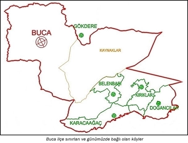
We will examine the villages of Kaynak (note 1), Kırklar, Belenbaşı, Doğancılar and Karacaağaç, which are connected to Buca, from a historical perspective. In addition to these villages, we will also look at Gökdere village, which, although connected to Bornova, has more commonality with Buca both in the past and today. With this exception, we will try not to go beyond the district borders of Buca. We will also talk about the ancient Karapınar waterway, which mostly passes through the territory of Buca. In this study, little-known information that has been uncovered so far will be highlighted. Some unknown information will be mentioned for the first time and will be further concretized through ground scanning.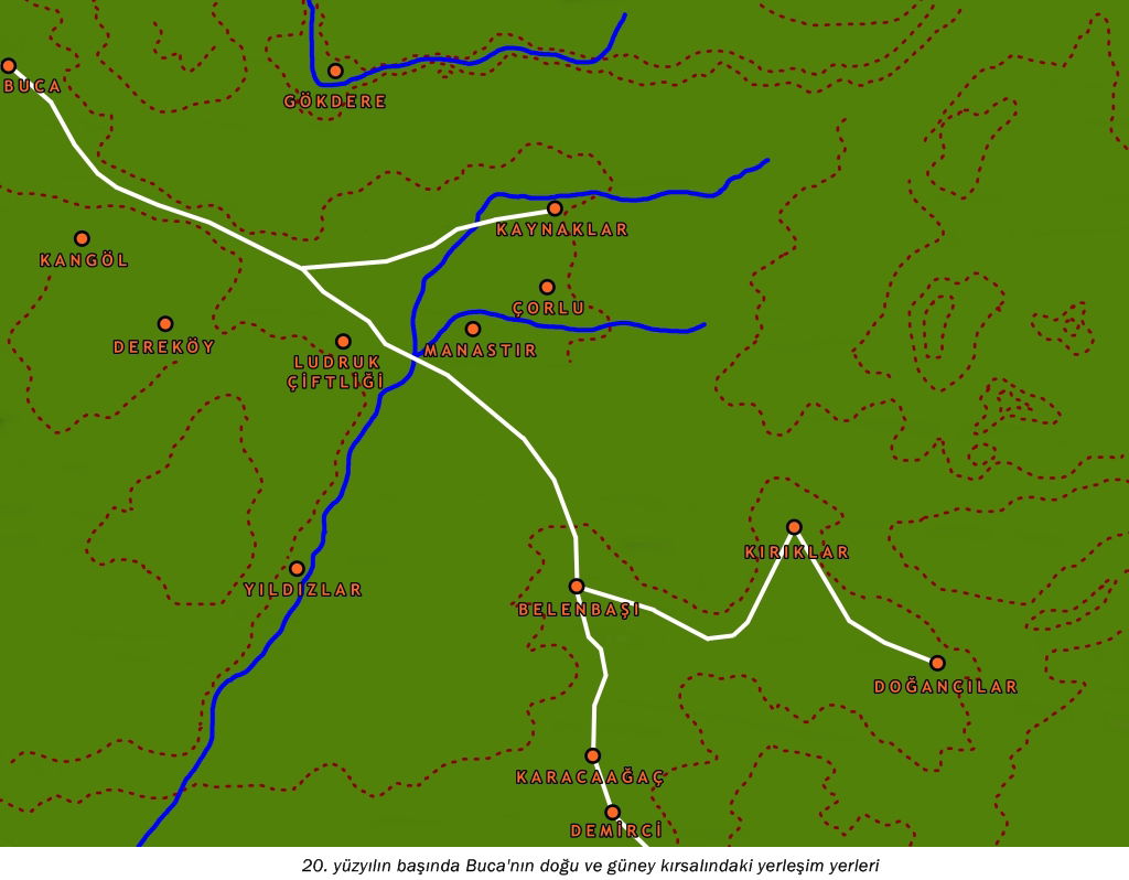
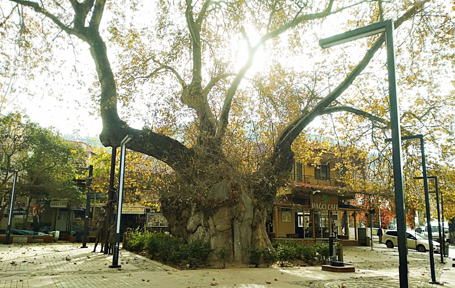
Among the villages of Buca, the closest and best known to Buca is Kaynak village. The first place that comes to mind is the village square and the huge trees there. A tributary forming the Tahtalı Stream passes through here, adding a beautiful atmosphere to the square. Resources village is also the most built-up village in Buca. The people have largely abandoned animal husbandry. Agriculture continues. However, if construction continues, question marks may arise about the future of agriculture. The fact that there is a great demand for the village from outside the village has increased the land prices. Naturally, many people started to sell their lands for construction. However, it is too early to say that Kaynak village has become concrete.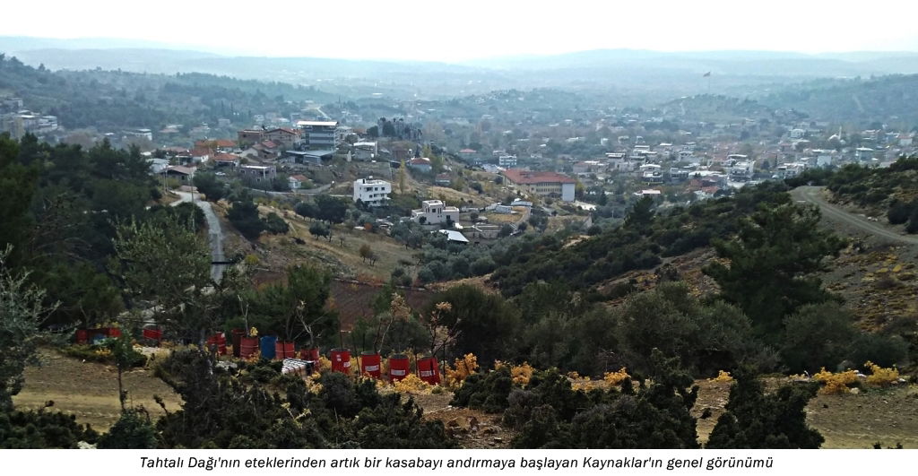
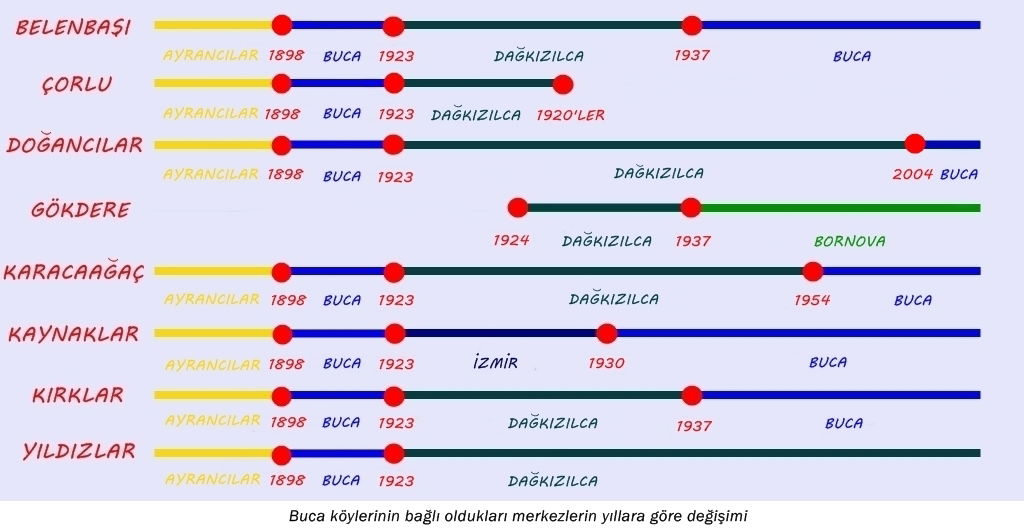
Most of the Yoruks in Anatolia had a nomadic lifestyle in the past. It is said that this lifestyle is a tradition inherited from Central Asia. The Yörük families who founded the Resources village also had a nomadic lifestyle in the past. Probably a group of Yoruk families planned to settle down in Resources and the village of Tahtalı, as it was known at that time, was established. Perhaps those who first founded the village in the early 1800s used this place only for winter and went to cooler areas in the summer. Thanks to old maps, it is certain that there was a permanent settlement in the village in the mid-1800s (note 2). It should be noted that the population of the village must have been quite small at that time. Even in 1891, the population of Tahtalı village was mentioned as 48 households and 273 people. David Forbes, from the Forbes family, a Levantine family from Buca, mentions Tahtalı village as a Yörük village consisting of 70-80 houses in a letter dated 1919. Considering that, according to the Turkish average of that day, five people lived in each house; The village population will not exceed 500 people. It is not known exactly how much Tahtali population was affected by the war. However, it seems that the population increased slightly after the war. According to the 1927-1928 Izmir Provincial Yearbook, the population of Tahtalı consisted of 108 households and was counted as 418 people. We can attribute this increase to migration from the Balkan geography. It is known that there are migrations to Kaynak village from some Balkan regions, especially Thessaloniki. In the 1920s, Tahtalı was the only village in the central district of Izmir, unlike other Buca villages. The other villages of Buca today were connected to Torbalı district at that time. Let us also remind you that Buca was not a district at that time and was a town connected to the central district of Izmir, like Tahtalı. It would be in 1930 that Buca would be merged with Kızılçullu, Tahtalı and Uzundere, which is now a part of Karabağlar, and turned into a township. Belenbaşı and Kırklar villages would also join the Buca township in 1937.
The population of the village was stated as 934 people in 1955. In other words, it has doubled in a period of nearly 30 years. It is necessary to allocate a separate paragraph here because during this period, Kaynak village received a significant migration from the Balkan region. This must be the main reason for the increase. Although the village of Kaynak is known as a Yörük village by its establishment, it also hosts a significant number of Balkan immigrants, which demographically distinguishes Kaynak from other Buca villages. The population of Resources village increased steadily in the following years. In the 1990s, when the village population exceeded 2000, it was converted into a municipality in 1998, in accordance with the law. Two neighborhoods were created in the municipality. In the west, there is the Izmir-Aydın highway and 29 Ekim District adjacent to Gökdere. In the east, there is the Merkez District, which includes the historical village and its surroundings and is adjacent to Nif Mountain and other Buca villages.
Locals of Resources village give some information about the history of the village. The village was a conservative place in the past. Women used to bow their heads while passing through the village square. This situation changed in the following years. Now the women of the village have started to earn money by selling the food, fruits and vegetables they produce in the square. The men of the village used to play games under the plane trees in the square in their spare time. There used to be more water flowing in the village square, but some of it has now disappeared. There were many families in the village coming from the Serres and Thessaloniki regions of Greece. In the past, tobacco growing and viticulture had an important place in the village. The first school in the village was built in 1932.
While talking about the history of sources, there is a village called Çorlu that has not survived to the present day but whose name should not be overlooked. This village was located on the western slope of the hill to the southeast, only 1.5 kilometers away from today's Resources Village Square. Frontrier mentioned in his book that there is a building here from the Middle Ages. In 1891, the population of the village was mentioned as 19 households and 230 people. This number is almost the same as Tahtalı at that time. According to the villagers, in the 1800s, Çorlu was used only as a pasture and people went to Ayrancılar for winter quarters. In the following years, when malaria broke out in Ayrancılar, Ayrancılar was completely abandoned and settled permanently in Çorlu. However, the village did not last long. They destroyed the village during the Greek Occupation. According to the villagers, a group of villagers came to Belenbaşı because the land was more suitable. Over time, other villagers left the village and settled in Belenbaşı. When we look at the 1923 data, the village is mentioned as a place with 14 households and a population of 126. This situation confirms what the villagers said. The village was not completely wiped off the map during the war, but it was obviously affected by the war and its population decreased. There is no mention of the village in later sources, which means that it was indeed abandoned in the 1920s.
When historical buildings are examined in Anatolian villages, there are not many historical buildings. The reason for this must be that in the past, villagers were not able to build buildings that would last for many years due to limited resources. It is seen that mostly mosques and fountains remain intact. Buca villages are not very rich in terms of historical buildings. However, historical buildings are not absent at all.
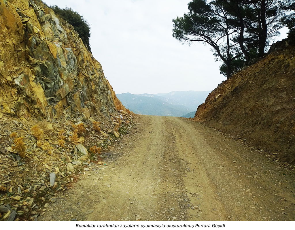
When you reach the Resources turnoff from the road coming from Buca, turn right and enter the road leading to Belenbaşı, you will continue for a while and cross the Tahtalı Stream coming from the Resources via the bridge. In the past, this road was used to reach regions further south, but it must have been a little further down the stream because there is a stone bridge just down the road. Aristote Fontrier, in his book Lembos Monastery, mentions that after passing Ludruk Farm, he crossed a bridge and came to a place called Çorlu. That stone bridge should be this bridge. The bridge was built with a typical Western Anatolian bridge architecture. It crossed the stream bed with a single, wide arch. In the past, there were two large floodwaters adjacent to the arch. Now only traces remain. The bridge was registered as a monument in 1998, but until recently it was subject to serious wear and tear due to vehicles passing over it. Still, it has managed to preserve its magnificence until today.


A place called Ludruk Farm is mentioned in some ancient sources and maps. According to Kararas, this farm was located 5 kilometers east of Buca, and today, when you go 5 kilometers east, you can reach Zafer District. The old people call the area where Zafer neighborhood is located "Olduruk". This name is still used from time to time today. The similarity of the words Olduruk and Ludruk also attracts attention. There is no evidence, but Ludruk Farm should probably be here. There is no other notable campus around Zafer District. The nearest vegetable market, Buca Pond and the lands around which the businesses are located were formerly fields and forests. Kararas referred to Ludruk Farm as a "big Turkish Farm". The village of Dri, which was previously a Byzantine village, stood on the site of this farm. Today, nothing remains of either the farm or the Byzantine village. It has turned into an ugly neighborhood with houses and industrial facilities. There are also the facilities of Bucaspor Club, which is adjacent to the campus.
In old sources, a place called Monastery is mentioned between Yıldızlar and Çorlu. Frontrier described this place as "one hour south of Tahtalı and two and a half hours from Buca, past the Tahtalı Stream." It is not clear exactly what is meant. There was probably an ancient ruin here rather than a settlement. There is a region called Monastir to the east of Kırklar village. However, it must be a different place, as it does not fit either the old maps or Frontrier's description.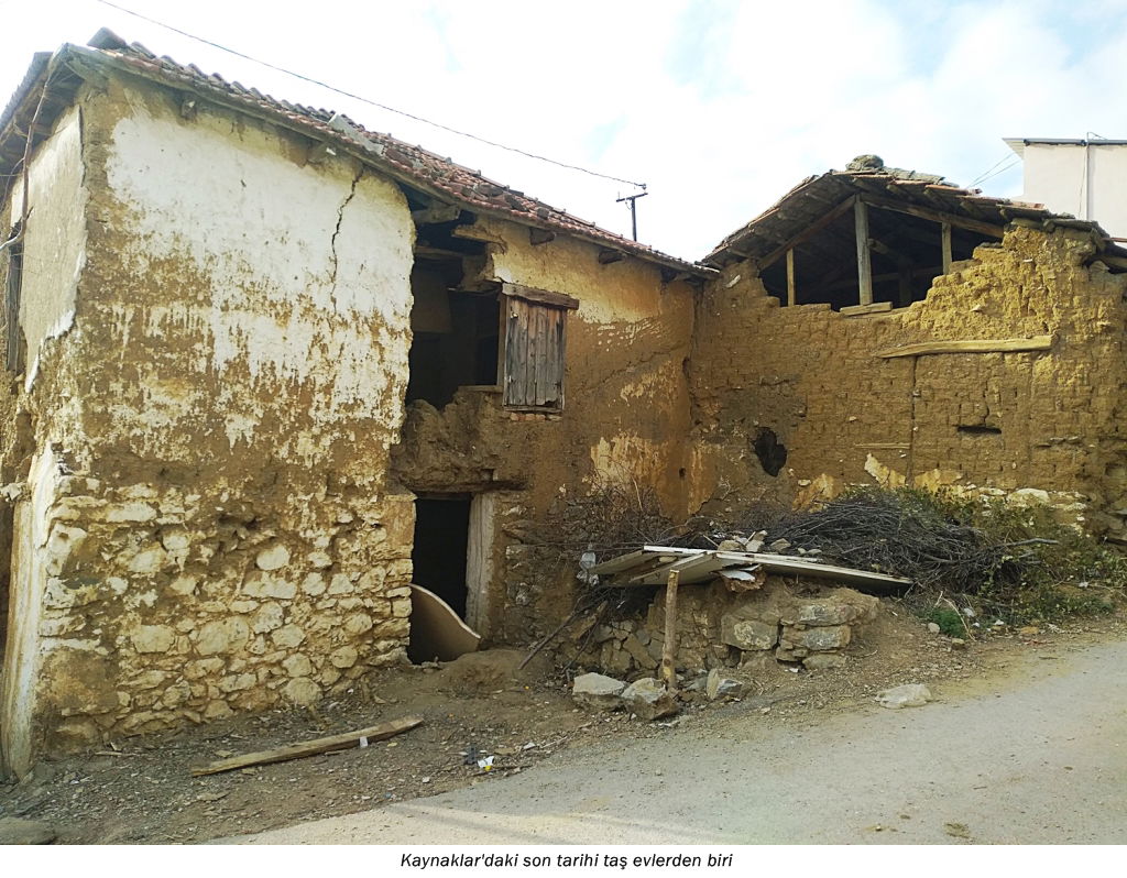
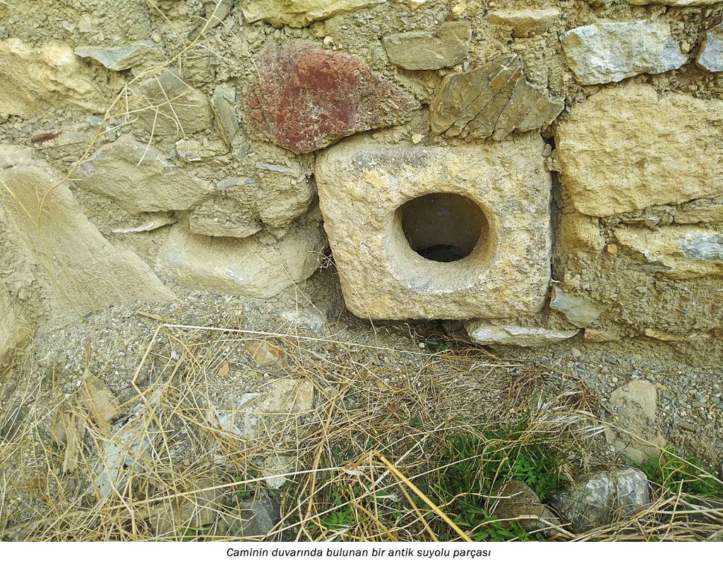
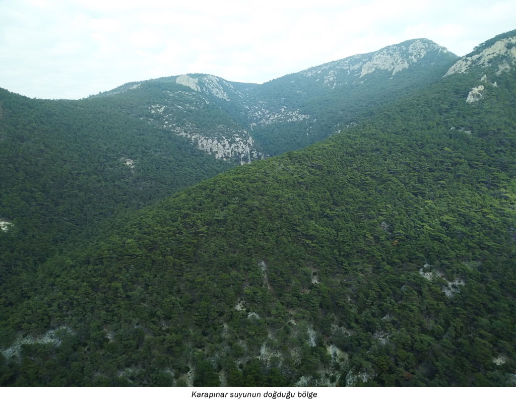
Before leaving the Springs area, let's go to the valley through which the Karapınar waterway, which met the water needs of Izmir in ancient times, passed. The Karapınar waterway does not pass completely through Buca. Some of it also passes through Bornova district borders. After Karakapı, it is included in the Konak district borders up to Kadifekale. However, it can generally be called a Buca waterway. Buca; Just like the Osmanağa, Vezirağa and Kozağaç waterways, the Karapınar waterway has a critical importance in terms of meeting the water needs of İzmir.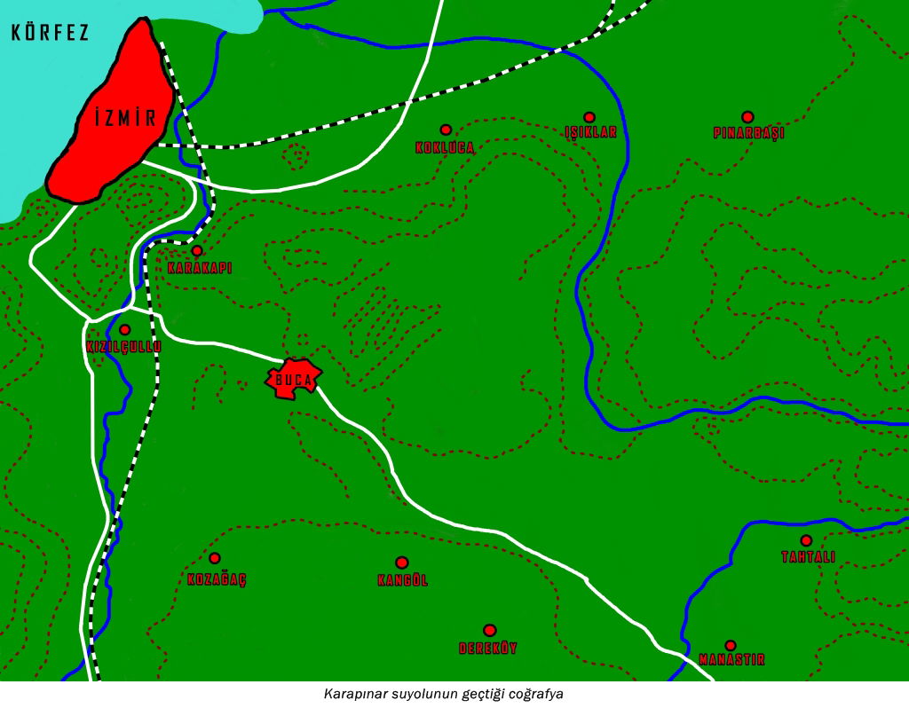
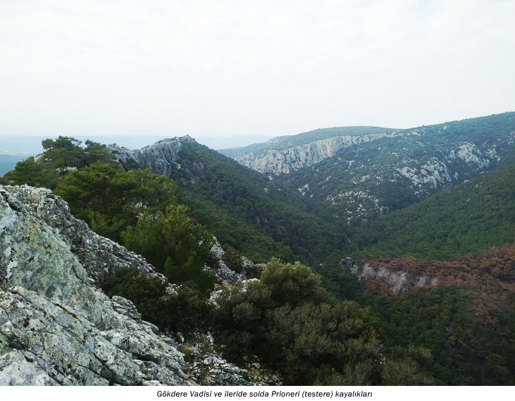
Before talking about Gökdere village, let's first describe Gökdere Valley with today's geography. The valley begins at the southernmost end of the Bornova Plain, at a point between Işıklar and Pınarbaşı. It proceeds south for approximately 4 kilometers and turns east from Gökdere village, continuing for another 8 kilometers and ending at a point close to one of the peaks of Mount Nif. The road passes through the part of the valley that goes down to the south, that is, to Gökdere village, and the stream part has also suffered great damage. Only the part of the valley that extends from Gökdere village to the east, that is, into the interior of Nif Mountain, remains natural.
Author Frontrier, in his book dated 1892, mentioned Gökdere, then known as Arapdere Valley, as "30 years ago it was an untouched valley, forested and a shelter for bandits, but now it is a valley with vineyards and agriculture." Arapdere used to flow so much in winter that it turned the mills in the region, but in summer and spring there was only water at the top of the valley (probably around Karapınar).
Gökdere water, which follows the Gökdere Valley and is named by the same name, turns towards the north when it reaches Gökdere village, and further on it rises to the Bornova Plain and finally flows into the bay from Halkapınar. Gökdere village, at this point where the stream turns, is actually within the borders of Bornova district. However, it has more relations with Buca than Bornova. For this reason, it is impossible not to mention Gökdere village, which can be considered more like a Buca village.
Due to the Turkish-Greek population exchange, there was migration from Lesbos to Anatolia in 1924. Among the immigrants, there are 30 Yörük households. 10 of these households come to this region where Yoruks are the majority. These families buy a large farm of 4,000 acres in the Arapdere region and establish the Gökdere village here. The name Gökdere is first encountered in the records of 1927-1928. The name of the region was changed to Gökdere after the republic, probably because the name "Arab" was mentioned in it. The village was mentioned as having 79 households and a population of 353. There has not been much change in the village population. The population of the village exceeded 400 people for the first time in 2019. However, it can be said that the natural structure of the village is under threat due to some factories and shops opened in recent years on Gökdere Street passing by the village.
– Belenbaşı village –
Descending south from the plain where the Springs are located, following the Tahtalı Stream, you arrive on the Buca road. From here, when you go about 4 kilometers to the east, rather than towards Buca in the west, you come across the village of Belenbaşı, which is built on a higher plateau compared to its surroundings. According to the villagers here, the name of Belenbaşı village comes from this altitude. The word Belen means "high place" in the Yörük language. As mentioned above, and according to some villagers, Belenbaşı was founded when the villagers of Çorlu village near Kaynak came here. However, when we look through the history pages, we see that the village may be older than thought. The population of the village in 1891 is mentioned as 46 households and 421 people. The name of the village is "Bilamebaşı". The population was quite large according to the conditions of the time. In addition, according to the data of 1905 obtained by the Belenbaşı Mukhtar's Office, there were 10 households and 312 people in the village. It is difficult to make a comment about the reason for this difference. A migration movement may have caused this. However, the fact that Belenbaşı village is mentioned as Belenköy on an old map and the village headman's office says that the old name of the village was Belen does not exclude the possibility that Bilamebaşı and Belenbaşı are not the same villages. We look a little further and look at the data for 1923, but although there are all Buca villages, Belenbaşı or a similar name does not appear. According to the 1927-1928 yearbook, the population of the village consists of 18 households and 110 people. Its population is quite small compared to the surrounding villages. All this information strengthens the thesis that the village is a newer village founded by villagers migrating from Çorlu.
According to the villagers, the founders of the village were Yoruks from the Karateke region of Antalya. The ancestors of these Yoruks settled in this region after living as nomads around Torbalı, Kemalpaşa during the 1800s. The first people who founded the village were a few families - probably from Çorlu. Later, new ones were added and the population increased. The population of the village increased to 225 in 1950 and to 430 in 1970. Afterwards, it grew rapidly and today it has a population of more than 1200. Although it is a village founded later than other villages, it would not be wrong to say that it is the second most popular Buca village after Kaynak. Since, unlike other Buca villages, there is no large elevation around it and the village itself is located on a slightly higher point, there has been a great demand for land here in recent years. The only downside is the unpleasant prison on the Kırklar road, less than 2 kilometers away.
Written information about the history of Buca villages is very limited. For this reason, what the villagers say becomes even more important. Older Belenbaşı villagers give important information about the village. We can assume that this information they provide is valid for more or less all Buca villages. After all, those who founded the villages all come from the Yoruk tradition and their ancestors are probably related families. According to the villagers, those who founded the village adopted a lifestyle based on animal husbandry in the early days. In fact, the summer pasture-winter lifestyle continued for a while after the village was founded. In the following years, agriculture dominated here as well. Tobacco was also grown for a while, but tobacco cultivation was abandoned due to the introduction of a quota on tobacco production in the 1990s. Nowadays, cherry, olive, fig and vegetable cultivation is at the forefront. There was no formal education in the village before 1960. Lessons were given at home. Those who wanted to study had to go to Buca. For this, the child had to go to Buca every day on horseback or donkey back, or the child had to stay with an acquaintance in Buca - if he had one. Since this is almost impossible, the literacy rate in the village used to be low, and we can assume that this situation is the same for all Buca villages. The first primary school was opened in 1960. In the past, there was an arranged marriage in the village. Consanguineous marriage was common. However, there was also exchange of girls with other villages. Weddings last three days and three nights, and men and women do not dance together. Zeybek and Çiftetelli were played as games. There was no coffee house in the village. They gathered in village houses. Drums and zurna were played in the village. Women played the dümbelek. Keskek and buttermilk are the most prominent dishes. The village, which preserved its old, modest structure until the 2000s and was largely composed of Yoruks, has received a significant number of immigrants from outside, especially in recent years. The lands were opened for development and the number of houses increased. Belenbaşı village also expanded outwards. There used to be no transportation to Buca in the village. The roads were made of dirt and very rough. During the period when animal husbandry was still intense, villagers would go to sell the leftover animal products in Buca. There was no newspaper in the village. From time to time, newspapers were dropped into the village by the state via plane. The first tractors came to the village in the 1950s, but there were only a few. After the 1970s, the number started to increase slowly.
There is no significant historical building in Belenbaşı, the newest village among the Buca villages.
– Kırklar village –
When you go over the hill to the east of Belenbaşı and go down, you come to a village surrounded by hills on three sides and leaning on the foot of Nif Mountain. This is Kırklar village. Like other villages in Buca, this is a Yörük village. His name is mentioned in the yearbook of 1891. It is known that it consists of 27 households and 161 people.
According to the villagers, there used to be forty deposits here. In addition, the number forty is sacred for the Yoruks. The name of the village comes from here (note 3). In 1923, there were 48 households and 167 people in the village. This number is shown as 62 households and 273 people in the 1927-1928 yearbook. From the numbers we can say that there are no major population fluctuations in the village. In 1955, the population increased to 552 people.
Like Belenbaşı, there are no significant historical buildings in Kırklar. Houses started to be built in a modern way rather than the old type of stacked stone. It is seen that a small number of old houses were either unused or converted into secondary residences such as barns.
It is impossible not to mention the old cemetery in Kırklar village. There are at least 200-300 historical gravestones in the historical cemetery on Doğancılar road. The gravestones belong to the Ottoman Period, but apparently no serious study has been done on these graves until now. However, a study that can be done here may reveal unknowns about Yoruk culture and history.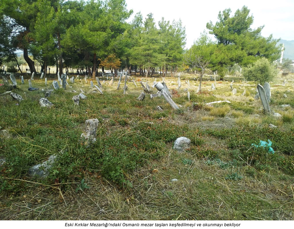
Doğancılar village is the close neighbor of Kırklar. It is located 2.5 kilometers southeast of Kırklar village. It was built on the southern foothills of Mount Nif, on a ridge that is higher than its surroundings. It has a more natural geography than other villages, thanks to its location away from main roads. Buca village has the least population. The history of the village dates back to the 1800s. In 1891, it was mentioned as a small village consisting of 23 households and 146 people. In 1923, it consisted of 36 households and 240 people. In 1927-1928, its population reached 52 households and 237 people. The village did not undergo a major population movement afterwards and even today its population is around 200.
No detailed information about the history of the village could be found, but it would not be difficult to guess that the village was founded by a Yörük group in the 1800s. The only notable historical building in the village is the Ottoman style village mosque built in 1945.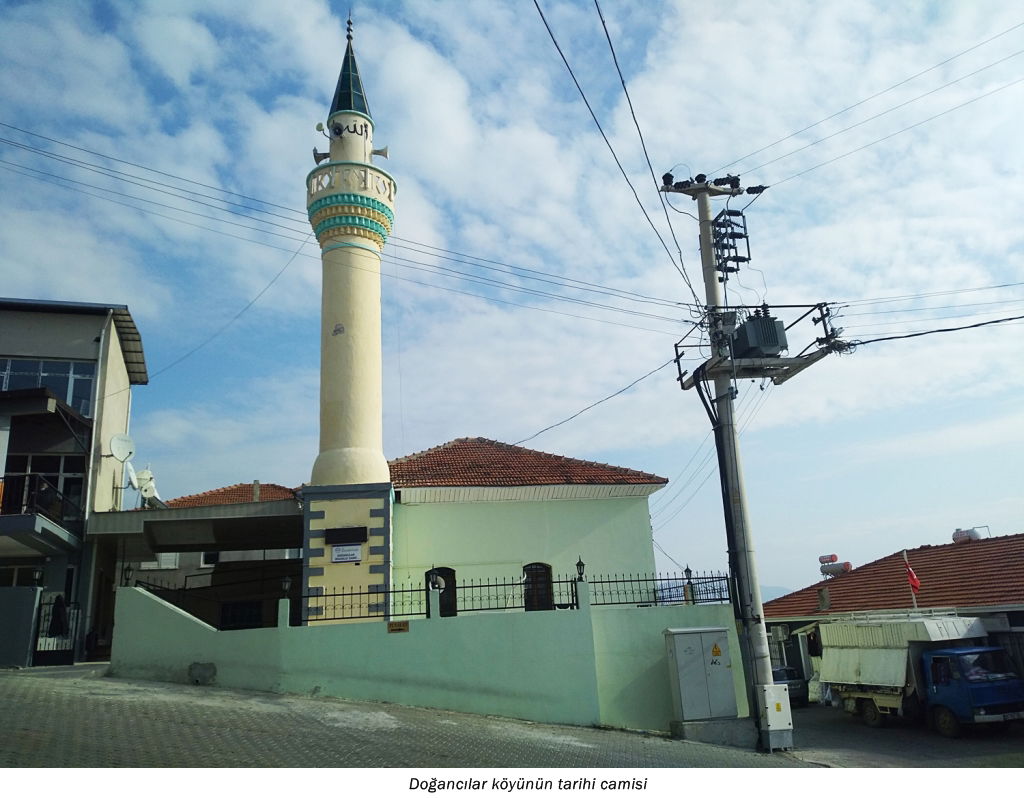
Karacaağaç village is located 2.5 kilometers south of Belenbaşı. There is Demirci village of Torbalı, on the Buca-Torbalı district border and just 1 kilometer south. Due to its location, Karacaağaç village, like Doğancılar village, has not undergone any major changes and has remained natural. In 1891, it was a village consisting of 30 households and 170 people. In 1923, it was stated that it consisted of 57 households and 168 people. In the 1927-1928 yearbook, it suffered a great wave of immigration with 71 households and a population of 351 people. The reason is not clear, but a group of immigrants may have been settled in the village. This needs to be investigated. In 1955, its population increased to 487. Afterwards, its population did not increase significantly and passed the 700-person limit for the first time in 2018.
The name Karacaağaç is clearly seen on maps from the 1800s, giving the impression that it is a very old village, although its name has never changed. Its foundation can be dated to the early 1800s and it must have been a village founded by Yoruks, like other villages. Although rare, it is also written as "Karaağaç" in some maps and sources. While it is called this way by some people, it may also be mistakenly understood as such.
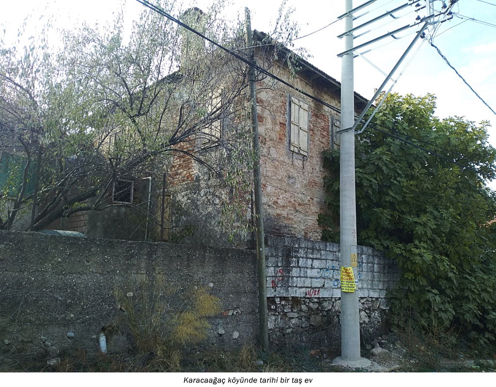
A few stone houses in Karacaağaç are remarkable. Apart from that, it is seen that the village architecture has decreased considerably compared to the past and has been replaced by modern style single and two-storey houses. The mosque of the village also has an Ottoman style architecture. No information could be obtained about its history, but its construction date can be traced back to the early 1900s.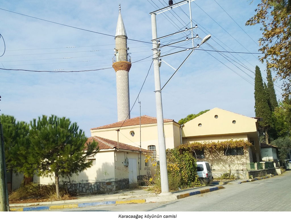
Finally, let's talk about the village of Yıldızlar, which is located 4 kilometers west of Belenbaşı, on the west bank of the Tahtalı Stream and where the highway passes next to it today. In fact, it was a settlement that was too small to even be called a village in the past, and was probably a hamlet created by Yoruks for animal husbandry purposes. It appears as "Saringi" on old maps. It can be translated into Turkish as Sarınç. Frontrier says in his book that Sarınç is a 2-hour walk south of Çorlu. He also adds this information: Just before coming to Sarınç, there was a place called Palyohori (Turkish: old village) with many ruins from the Byzantine Period. The only significant data about the population of Sarınç is the data of 1923. There were 15 households and a total of 30 people lived in the place called "Sarınç Farm". There is no information about why and when the name was changed to Yıldızlar. Stone houses still exist in the village, which has a population of around 700 today. Of course, it has lost its former remoteness due to the Izmir-Aydın highway passing next to it, but since there is no significant settlement around the village, it can be said that it still preserves its naturalness to a great extent.
– Epilogue –
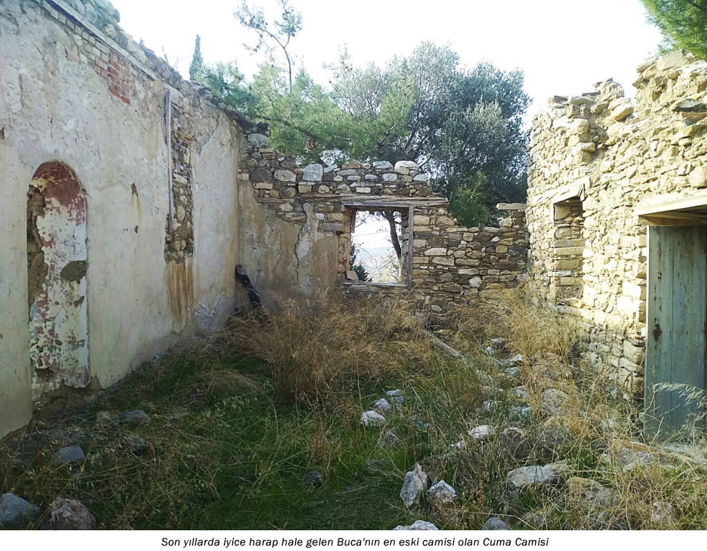
After visiting the villages in the eastern and southern rural areas of Buca, the first impression is that the villages have undergone much more change than Anatolian villages. There are almost no historical stone houses in all the villages. Most of the ones that exist are either abandoned or in barns, etc. It is used for different purposes. Very few stone houses were found that are still in good condition. It seems that some historical houses were covered with plaster. This makes it difficult to determine whether the houses are historical or not. There are historical mosques in three of the five Buca villages (Doğancılar, Karacaağaç, Kaynak). These are the structures that can be called remarkable historical buildings.
There are a surprising number of Ottoman Era gravestones in the cemeteries of Buca villages. The cemetery of Kırklar village hosts both old and new graves, but the area with old gravestones covers a very large area. There are also a considerable number of Ottoman Era tombstones in the Kaynak village. A small number of historical gravestones were also found in Belenbaşı. Considering that the population of the villages was very low in the Ottoman Period, a surprising calculation emerges.
The exact location of the historical regions called Çorlu and Manastır could not be determined. Only its estimated location is known. The fact that the lands in the plain are very densely parceled and most of the land is fenced by private landowners makes a comprehensive land survey in the region impossible.
It seems that the resources area is under dense construction. Surprisingly, there are traces of construction and people even in the lands at the foot of Tahtalı Mountain, above the village of Kaynak. With the vehicle roads opening into the interior of Tahtalı Mountain, more human impact is also invited. If construction and land sales continue at this pace, the Resources region may become unrecognizable within 10-15 years. The construction of Kırklar Prison has also caused great damage to the Kırklar region, and as the structures related to the prison continue to expand, the nature and agricultural lands in the Kırklar region are in danger of a great shrinkage. Necessary steps need to be taken to prevent Buca villages, which are a place of escape for the people of Buca, from being subjected to further construction.
- Additions -
| Name of village (old name) | 1891 | 1923 | 1927 | 1935 | 1950 | 1960 | 1970 | 1980 | 1990 | 2000 | 2013 | 2019 |
| Belenbaşı (Bilamebaşı) | 421 | - | 110 | 159 | 225 | 313 | 430 | 540 | 647 | 722 | 973 | 1281 |
| Çorlu | 230 | 126 | - | - | - | - | - | - | - | - | - | - |
| Doğancılar | 146 | 240 | 237 | 252 | 293 | - | 320 | 286 | 269 | 277 | 204 | 243 |
| Gökdere | - | - | 353 | - | - | - | 182 | 208 | 337 | 403 | 366 | 402 |
| Karacaağaç | 170 | 333 | 351 | 364 | 469 | 474 | 645 | 751 | 1061 | 941 | 654 | 708 |
| Kaynaklar (Tahtalı) | 273 | - | 418 | 585 | 810 | 1006 | 1082 | 1426 | 1946 | 3771 | 2256* | 2564* |
| Kırklar | 161 | 355 | 273 | 356 | 521 | 592 | 593 | 551 | 599 | 1041 | 1625 | 1789 |
| Yıldızlar (Sarnıç) | - | 30 | - | - | - | - | - | - | - | - | 601 | 734 |
-----------------------------------------------------------------
This article was created by atalarimizintopraklari.com. All rights reserved. All or part of this article cannot be used in books, magazines or newspapers without citing the source.
- Footnotes -
1-) Kaynaklar is officially a neighborhood but will customarily be called a village.
2-) The place called "Live Kese" on the Thomas Best Jervis map dated 1855 cannot be anywhere other than Tahtalı.
3-) The name of the village changed to Kırıklar in the 1930s, probably for political reasons. In August 2020, the village regained the name "Kırklar".
– Sources –
1-) Aydın Vilayeti Salnamelerinde Torbalı ve Sultan 2. Abdülhamid’in hayır eserleri, Yasin Kayış.
2-) David Forbes’in 31 Mayıs 1919 tarihli, Amerikan Komisyonu’na yolladığı mektup.
3-) 1923 senesi İzmir Vilayeti İstatistiği, 1. Kitap.
4-) Buca Survey: 2016-2017 yılları mimari tespit çalışması, Ali Kazım Öz-Muammer İreç.
5-) Le Monastère de Lembos, Aristote Fontrier.
6-) Wasserleitungen von Smyrna, Georg Weber, 1899.
7-) T.C. Cumhurbaşkanlığı Devlet Arşivleri Başkanlığı
8- ) Türkiye İstatistik Kurumu
9-) Belenbaşı Köyü’nde sözlü tarih çalışması – Sefa Yapıcıoğlu, Ferdi Arslan